The Gulf of Mexico is basically the bit of water contained if you draw a line from the eastern tip of the Yucatan Peninsula to the western tip of Cuba and then a second line from the northernmost point of Cuba to the southernmost point of Florida. The stuff off the north coast of South America is all the Caribbean Sea
Because if you define it the way I described, you’re referring to a relatively well-contained patch of water as far as seas go. It’s like asking why Romania doesn’t border the Mediterranean: the Turkish straits are enough of a barrier for it to be useful for us to consider the Black Sea a separate thing.
With the Gulf of Mexico, the gaps between Mexico and Cuba and Cuba and Florida are narrow enough the it affects the behaviour of the tides, and historically if you controlled one of those three points you could make it difficult for someone else to get past you into the gulf. If you combine it with the Caribbean you’ve now got one name for patch of water even though it’s in two halves of that are quite meaningfully different and divided from one another. You’re right that it’s ultimately just whatever we decide to call it, but defining the gulf as the bit northwest of Cuba has historically been useful so it’s where the definition settled

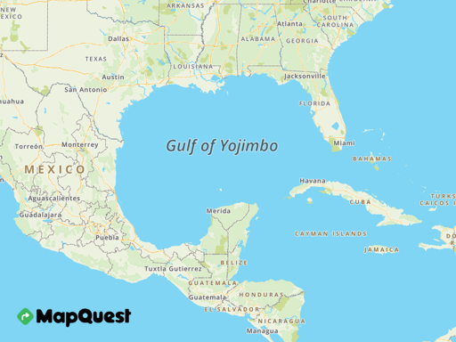
Is the northern part of South America not considered to border the gulf?
The Gulf of Mexico is basically the bit of water contained if you draw a line from the eastern tip of the Yucatan Peninsula to the western tip of Cuba and then a second line from the northernmost point of Cuba to the southernmost point of Florida. The stuff off the north coast of South America is all the Caribbean Sea
Yeah but it’s all arbitrary anyway though. Why does Cuba border it but Panama or Costa Rica does not?
Because if you define it the way I described, you’re referring to a relatively well-contained patch of water as far as seas go. It’s like asking why Romania doesn’t border the Mediterranean: the Turkish straits are enough of a barrier for it to be useful for us to consider the Black Sea a separate thing.
With the Gulf of Mexico, the gaps between Mexico and Cuba and Cuba and Florida are narrow enough the it affects the behaviour of the tides, and historically if you controlled one of those three points you could make it difficult for someone else to get past you into the gulf. If you combine it with the Caribbean you’ve now got one name for patch of water even though it’s in two halves of that are quite meaningfully different and divided from one another. You’re right that it’s ultimately just whatever we decide to call it, but defining the gulf as the bit northwest of Cuba has historically been useful so it’s where the definition settled