

List video game musics that would go nicely along with this one in a “scientific diagrams that look like shitposts” video!
Thats honestly fantastic lol
Unlike the human head, the earth actually is nearly spherical. There’s got to be some differences in how spherical projections work when the object actually is a sphere, I would think. I know that 2D maps are distorted, but are globes actually this distorted as well? Never knew that, if so.
Edit: After reflecting on it for a minute, I see they’re demonstrating forms of 2D map distortion. The way depth is represented is variable. With modern concepts of 3D imagery, we must have solved this distortion problem. If you open up Google Earth’s globe, it doesn’t have such distortion.
All 2D projections are distorted, but some are useful in certain contexts (yes, even Mercator, though not for viewing the entire globe at once). Google Earth is still projecting the image of a globe onto a 2D screen, and there are distortions.
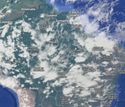
Here’s South America straight on in Google Map’s globe view:
And South America from the side:
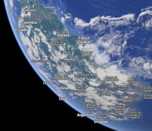
If you measure the distances between, say, Manaus and La Paz with your fingers in these pictures, you’ll get different answers. That’s just how translating a 3D object to a 2D image works; you can’t flatten a globe into a piece of paper without breaking something.
Thank you for illustrating for me. I understand what you’re saying.
With modern concepts of 3D imagery, we must have solved this distortion problem.
? You’re still taking a three dimensional earth and displaying it on a 2d screen or plane. That will always have distortion on some axes. That’s not a technological “problem” to be “solved”, that’s just mathematical reality.
Yes, that’s my point, we have computers that can pretty accurately represent depth, not like the old projections we drew on maps. Stretching it out flat (zooming in on google earth) has less distortion than these projections shown here, don’t they?
This has got to be wrong. A human head, projected like a world map, would show both eyes and both ears, except in the case of showing only one half (like when you only show/photograph the Americas).
This appears to take a picture of the side of the head (i.e. that particular projection, showing less than half of the full globe), then distort it as if it were already a different projection.
Edit: worse than that. The globe onto which the half-head-image is superimposed in the top right is larger than the head. Like if you took a photo of the Americas half of the world from space, pasted that onto a larger beach ball, then stretched the result to demonstrate the projections.
For a better visualization of how a human would look on the mercator projection, look no further than old games’ 3D textures, like this one from Half Life: https://www.textures-resource.com/fullview/6384/?source=genre
Taking a second look at that, though - is that really a continuous projection? Or is that storing different parts as different chunks (and maybe projected differently) put together into the one image?
Some parts are continuous projections, like the face and torso, which are “closed” geometric objects. I don’t know exactly how the HL human mesh is, whether separated in different chunks or fully joined in a single 3D object, but either would work if the faces are properly pointed to the specific pixel regions
Huh, neat!
Possibly. I asked (and no one’s answered yet, so I still don’t know) if it’s still a Mercator projection if you vertically bisect a map of the Earth.
Yes. Why wouldn’t it be?
Projections don’t have to be limited to the entire earth. You can subset the area represented and still apply a projection. (Though you do have a decision if you’re taking an arc-area to “re-align” your projecting shape so that it best fits your area. But that might be more complicated than you’re looking for, other projections best suited for your locale would be a better fit)
It’s still a Mercator projection if you take any part of a map projected thusly. (And there’s the “modified universal transverse Mercator” that, I think, is that with some grid offset.)
But, see my edit, this image isn’t doing that. It’s stretching a “picture of half a face superimposed on a larger half globe,” not the half-face as if the head were the globe.

Chad projection.
That’s Gall-Peters, isn’t it?
The virgin Globular map vs the chad Mercator map

Potion seller. I’m going into battle and I need your strongest potions.
You can’t handle my strongest potions traveler
Now do my dick
=o
Surprisingly informative
That looks pretty accurate for me
deleted by creator
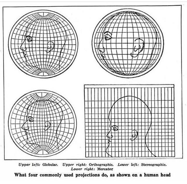
I don’t quite get this. The human head, like the globe, is not flat. Shouldn’t that be reflected in the projections? When projecting the earth in Mercator, we see the whole earth, not simply a “profile” of earth. I would expect a projection of a head to include the whole surface of the head, not a simple profile. How is this actually factual?

Same thought, ha.
This isn’t representing projections of a human head. This is representing projections of the globe if the globe had a giant human head drawn on it instead of the continents.
But then you have to figure out how to transfer the drawing of the head onto the curved surface, and how you do that is going to determine how the projections look.
No, you can ignore that part. The image isn’t showing how to accurately draw a head onto a surface, it’s showing how this given head drawing would look in different projections.
This is a better example
That is also a good explanation for how the Shroud of Turin could not possibly be an after-image of a three-dimensional person.
ptsd from modding kicks in
It’s still a Mercator projection if you take a world map done in that way and cut it in vertically in half, isn’t it?
Which should I use when sending one of my “special” DMs?
I don’t know, and I’ve also never used a dating app, but I’m swiping whichever direction means “no, I only date people with normal heads.”
What about people in robes and wizard hats
They’re not people, they’re rhinoceroses.
They could be both…
it’s a very effective hat
A hat is one thing, but at least it’s not a shirt. Rhinoceroses don’t wear shirts.
seriously you’ve gotta see this hat. you won’t be able to tell it’s a rhino when it’s got it on

That’s it. The rhino is fucking charging your ass.
OK, now show us the Goode homolosine equal-area projection human head.
I would, but I have a weak stomach.
So how about the Cahill Butterfly projection, …
Came here to say this, but you did, so I’ll ask for the Dymaxion projection.
I’d say that people who like the Cahill butterfly have bad taste, but then again, I might be projecting.
Ba-da-ching!


